
It’s a pretty nice jump.
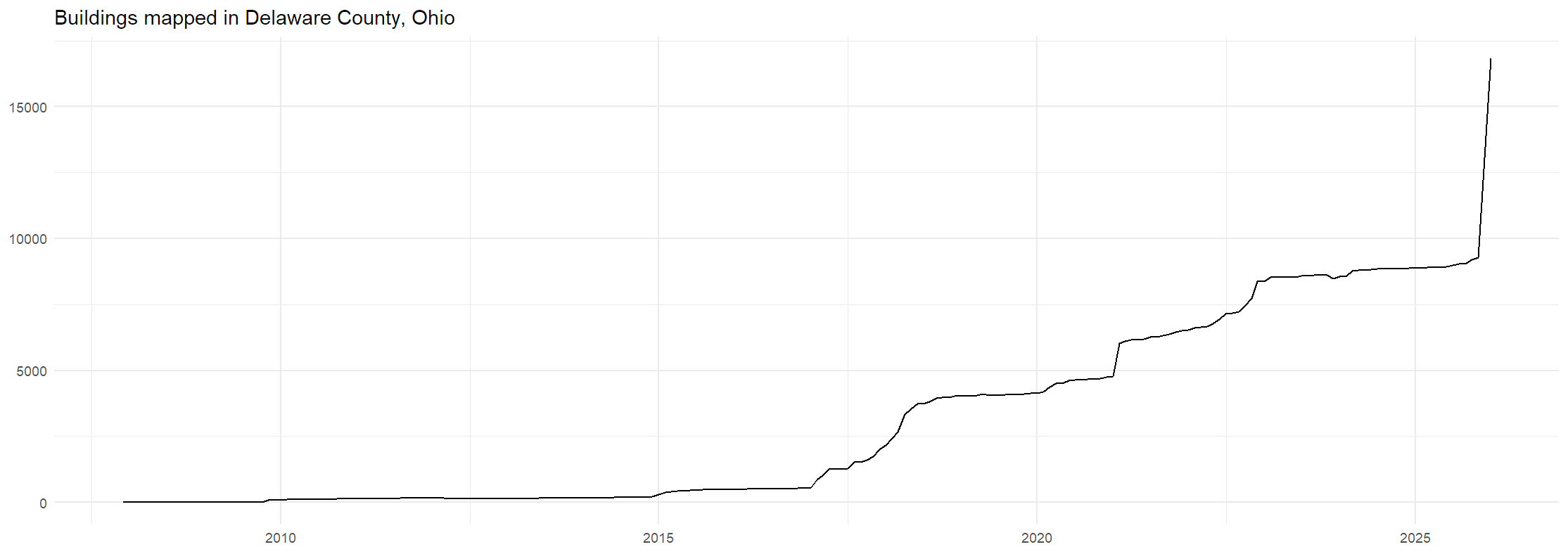
On November 4th, 2025, I noticed that there were 9,566 buildings mapped in Delaware County, and told a few friends that I wanted to push it up to 10,000. Since then, I’ve been mapping buildings in Delaware County daily, averaging over 100 buildings per day. Once I got it past 10,000, my next goal was to get it so that building mapping in 2025 would outpace building construction in the county. Delaware County is a rapidly growing county, so I did some napkin math and guessed that there were about 1500 buildings added to the county in the year. By the end of the year, I had easily surpassed that goal, and was now working to push back that date of keeping pace with construction further and further. You can see that in this graph:
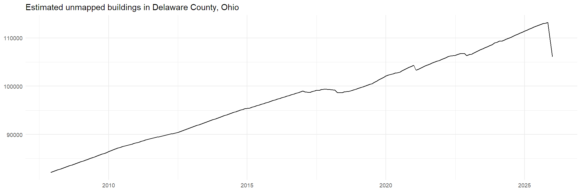
The estimate I used for this graph is quite simply that the number of buildings is half of the number of residents of the county. This probably isn’t a great estimate, and I’d love if someone knows how to pull better estimates from somewhere, but it’ll do for now. Based on this estimate, we’ve only kept pace with new construction since 2022 or so. There’s lots of work left to do!
A few other highlights from the past couple months:
-
I mapped all buildings and most landuse in Marlboro Township, the county’s smallest township by population.
-
Relatedly, I added a good chunk of forest landuse around the Delaware and Alum Creek reservoirs, with more left to do.
-
I significantly improved the fairgrounds, with plans to do more once I have the chance to make a trip there in decent weather. Hopefully, OSM-based apps will be a competent navigation aid during the next fair.
-
I recently started tackling the over 600 unnamed highway=residential ways in the county. Some of these are miscategorized, most of them are new construction that needs someone to visit it in person. I’m trying to remember to take some detours whenever I drive by one of those areas. Some of these might also have available streetside imagery, I haven’t checked.
Discussion
Comment from Strubbl on 16 January 2026 at 22:14
Nice graphs, that made me map some more buildings to even more increase the jump.
Comment from Minh Nguyen on 18 January 2026 at 17:47
Love what you’ve done with the fairgrounds! By the way, the thing that spells out “Little Brown Jug” is a classic case for a multilinestring. Now that you know, you’ll see these things everywhere and won’t be able to resist the urge to map them.
Comment from TopoNick on 18 January 2026 at 19:23
Great work! How did you pull the building count for this county? Is there a website that does that or you had some coding to do?
Comment from mottiger on 23 January 2026 at 10:42
Such a lovely project, I hope you are fine that I added some buildings. The bing imagery is crispy clear and it is really fun to finally map some buildings. Especially when I know that local people care about.
Comment from Eiim on 23 January 2026 at 18:27
@TopoNick I pulled the data using https://dashboard.ohsome.org/. I’ve done some more manual stuff in the past too but they make it pretty easy.
@mottiger Always great to have others working on this area!