SomeoneElse's Comments
| Post | When | Comment |
|---|---|---|
| Things you only find in OSM no 94... | Ah - I see what you mean. The tricky bit might be “recording the absence of something that isn’t very common, and doesn’t usually occur with that object anyway”. |
|
| Things you only find in OSM no 94... | @mmd If there’s a pub, and there’s a railway real-time departures board there, where do you think the pub is likely to be? :) |
|
| In order to get my business location on the map do i need to add it to bing maps | There’s no review needed in OSM. I can see it already at https://map.atownsend.org.uk/maps/map/map.html#23/53.34999/-6.24903 :
|
|
| Trackers? | Could you perhaps provide a few more details? What, exactly happened? |
|
| নাগা বাজার–মৌলভীবিভা সড়ক সংলগ্ন গ্রামীণফোন টাওয়ার ম্যাপিং অভিজ্ঞতা | Hello NagaBazar, I have hidden your latest diary entry as (yet again) it was written in Bengali but posted with a language of “English”. Please post it again, but this time set the language to Bengali. Best Regards, Andy, from OSM’s Data Working Group. হ্যালো নাগাবাজার, আমি তোমার সর্বশেষ ডায়েরিটি লুকিয়ে রেখেছি কারণ (আবারও) এটি বাংলায় লেখা হয়েছিল কিন্তু “ইংরেজি” ভাষা ব্যবহার করে পোস্ট করা হয়েছিল। দয়া করে আবার পোস্ট করুন, কিন্তু এবার ভাষাটি বাংলায় সেট করুন। শুভেচ্ছান্তে, ওএসএমের ডেটা ওয়ার্কিং গ্রুপ থেকে অ্যান্ডি। |
|
| From Mapping to Validation: My Growth Journey in the ESA validation Fellowship | Hello - just in case you’re not aware, this diary entry got a mention at https://community.openstreetmap.org/t/unite-inspire-innovate-my-transformative-journey-at-state-of-the-map-asia-2024/123580/6 . You might want to pop in there and say hello! |
|
| Growing Through Validation: My ESA HOTOSM Fellowship Journey | Hello - just in case you’re not aware, this diary entry got a mention at https://community.openstreetmap.org/t/unite-inspire-innovate-my-transformative-journey-at-state-of-the-map-asia-2024/123580/6 . You might want to pop in there and say hello! |
|
| MY ESA VALIDATION FELLOWSHIP JOURNEY | Hello - just in case you’re not aware, this diary entry got a mention at https://community.openstreetmap.org/t/unite-inspire-innovate-my-transformative-journey-at-state-of-the-map-asia-2024/123580/6 . You might want to pop in there and say hello! |
|
| From Doubt to Data Quality: My Journey with the ESA Hub Fellowship | Hello - just in case you’re not aware, this diary entry got a mention at https://community.openstreetmap.org/t/unite-inspire-innovate-my-transformative-journey-at-state-of-the-map-asia-2024/123580/6 . You might want to pop in there and say hello! |
|
| নাগা বাজার–মৌলভীবিভা সড়ক সংলগ্ন গ্রামীণফোন টাওয়ার ম্যাপিং অভিজ্ঞতা |
|
|
| নাগা বাজার–মৌলভীবিভা সড়ক সংলগ্ন গ্রামীণফোন টাওয়ার ম্যাপিং অভিজ্ঞতা | Below the diary entry you write there is a field “Language”. You MUST change that to match the language you have written your diary entry in so that people looking for that language will see it. আপনার লেখা ডায়েরির নীচে “ভাষা” নামক একটি ক্ষেত্র আছে। আপনার ডায়েরির এন্ট্রিটি যে ভাষায় লেখা হয়েছে তার সাথে মিল রেখে আপনাকে অবশ্যই এটি পরিবর্তন করতে হবে যাতে সেই ভাষা খুঁজছেন এমন লোকেরা এটি দেখতে পান। |
|
| Proposal - Ratify OSM Bunker/ Pillbox nodes, using external data sources | Yes, this should be discussed in the UK forum. With any import like this, conflation is the key. Where there are discrepancies either side here could be correct, and given that this can be fairly hidden, a survey will often be needed to resolve. I’d also suggest that your proposed tagging seems to miss one very important thing - whether a bunker is in active use by the military or not! An overpass search here finds a bunch that surely are active and a bunch that surely are not. Not all the inactive ones are tagged as such, and where they are OSMers have used a wide range of tagging. I’d instead suggest perhaps |
|
| A Shortbread map style that looks a bit less beige | @Zverik OK, fixed. https://map.atownsend.org.uk/vector/index_osmf_shortbread.html#17.59/59.389977/24.717497 looks more sensible now. There are a couple of other bugfixes that could do with merging into this style too; I’ll do that as time permits in the coming days. |
|
| A Shortbread map style that looks a bit less beige | That’s a In the style that I used the cartography from I eventually changed that (see https://map.atownsend.org.uk/vector/index_svwd01.html#17.59/54.551428/-1.904913 ) so it should just be a case of merging that change into this style too. |
|
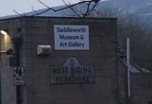
| Rearranging the world around Nominatim for fun and profit | Obviously me using traditional counties in the example above is a bit of a joke, but some people do seem to take it seriously. I was in this pub earlier today, and the landlady was very insistent that it was in Yorkshire not anywhere else. She’d agree with my joke server about the county: although it’s chosen the street name from the back door rather than the front. Further up the road the museum has this sign on the wall:
so it’s not just her! |
|
| Why is showing pedestrian crossings so complicated? | @kumakyoo You can see the code I’m using at https://github.com/SomeoneElseOSM/SomeoneElse-style/blob/master/shared_lua.lua#L7373 , but answering your questions:
Yes, I’ll show any of those as a
No, without infrastructure that wouldn’t.
Yes - that’s exactly the point I’ve made at various places in https://community.openstreetmap.org/t/separate-sidewalks-or-not-near-ealing/132613 and similar threads.
I believe that it makes sense to do that too, although there are edge cases where some other |
|
| Léarscáil 2025 | I bet you could search for “common Irish words” to identify some of them, for example this overpass query searches for “Bóthar” in |
|
| Léarscáil 2025 | What about things that have Irish names only, like this road? That just shows as this. I presume it’s in a Gaeltacht that far west in Galway, hence |
|
| Why is showing pedestrian crossings so complicated? | @cquest Interesting - is there a link to the tags used anywhere? |
|
| Rearranging the world around Nominatim for fun and profit | That’s surprisingly accurate :) |